Flatadyngja

"Flatadyngja is a very low shield volcano at the SE foot of Kollóttadyngja and 8 km west of the summit of Herðubreið, which forms only a slight bulge in the contour lines of the 1 : 100.000
map, with a maximum altitude of 750 m. It was for the first time recognized as a small shield volcano by Spethmann (1914, p. 372). The lavas of this depressed lava cone flowed northeast and
eastward around Herðubreið. The eastern flows passed through the gateway between Herðubreið and Herðubreiðartögl, and then spread fan-like to the Jökulsá á Fjöllum and Eyvindarkofi, forming a
rough apalhraun with patches of windblown sands in the depressions.
[...]
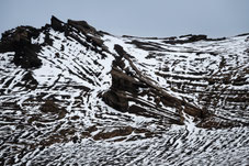
The crater on top has a N-S diameter of 625 m and shows nested sinks, partly with inward tilted lava blocks and wide fissures and craterpits along the margins. In the centre of the sink are some smaller craterpits and a miniature cone of ejectamenta.
[...]
This shield volcano is definitely younger than Kollóttadyngja, but older than the outflows from the fissure of Dyngjufjölltindar*."
- R.W. van Bemmelen and M.G. Rutten: Tablemountains of Northern Iceland, Utrecht 1955 -
*) Dyngjufjölltindar = Dyngjufjallaháls

Picture of the Month